
A DESCRIPTION OF THE
RHODE ISLAND RESOURCE PROTECTION PROJECT GIS DATA LAYERS
The Rhode Island Resource Protection
Project developed a series of GIS maps that detail statewide resources.
The following tables provide a complete description of the data
layers used by the project. This information is intended for planning
purposes only; please contact the agency listed as "Data
Source" if you have any questions about the information.
KEY
ASA - Applied Science Associates, Inc.
DEM - Rhode Island Department of Envrionmental Management
DOH - Rhode Island Department of Health
NRCS - Natural Resources Conservation Service
RIGIS - Rhode Island Geographic Information System
US EPA - United States Environmental
Protection Agency
WATER SUPPLY RESOURCES
MAP
|
| ||
| Areas Served by Public Water Supply | Areas serviced by public water supply delivery systems. | ||
| Community Wells | Public wells serving at least 25 residents or 15 service connections year round. | ||
| Groundwater Recharge Areas | Critical portions of recharge areas for major groundwater aquifers suitable as sources for untreated drinking water. | ||
| Groundwater Reservoirs | Major groundwater reservoirs for aquifers classified as GAA or GB by DEM. | ||
| Non-Community Wells | Public wells serving at least 25 persons at least 60 days of the year. | ||
| Sole Source Aquifers | Areas designated as sole source aquifers by US EPA. | ||
| Surface Water Reservoir Watersheds | Surface water drainage basins for public drinking water reservoirs. | ||
| Surface Water Reservoirs | Surface reservoirs used as sources for public drinking water supplies. | ||
| Watershed Boundaries | Surface water drainage basins and sub-basins in Rhode Island, Connecticut and Massachusetts. | ||
| Well Head Protection Areas | Areas around community and non-community wells which are critical for protection of their source water supplies. |
AGRICULTURAL AND FORESTRY
RESOURCES MAP
|
| ||
| Agricultural Land - Prime Farmland Soils | Land use designation as agriculture (from aerial photography coded to Anderson modified level 3 to one half acre polygon resolution) that overlaps with designated Prime Farmland Soils. | ||
| Agricultural Land - Non-Prime Farmland Soils | Land use designation as agriculture (from aerial photography coded to Anderson modified level 3 to one half acre polygon resolution) that does not overlap with designated Prime Farmland Soils. | ||
| Forested Land - Prime Farmland Soils |
| Land use designation as forested (from aerial photography coded to Anderson modified level 3 to one half acre polygon resolution) that overlaps with designated Prime Farmland Soils. | |
| Forested Land - Non-Prime Farmland Soils | Land use designation as forested (from aerial photography coded to Anderson modified level 3 to one half acre polygon resolution) that does not overlap with designated Prime Farmland Soils. | ||
| Other Prime Farmland Soils |
| Soil type delineated and classified by Natural Resources Conservation Service as Prime Farmland that does not register active agricultural or forested use by 1988 land use designation. Does not include any area that has been developed for residential, commercial, industrial or recreation use. |
POTENTIAL THREATS TO
NATURAL RESOURCES MAP
|
| ||
| Dams | Man made dams as shown on USGS 7.5 minute quad maps not associated with anadromous fish runs (either existing or with restoration potential). | ||
| Dams with Fish Ladders | Dams identified by DEM Division of Fish, Wildlife and Estuarine Resources on existing anadramous fish runs that have fish ladders. | ||
| Dams without Fish Ladders | Dams identified by DEM Division of Fish, Wildlife and Estuarine Resources on existing anadramous fish runs or anadromous fish runs with restoration potential that do not have fish ladders. | ||
| National Priority Listings (NPL) |
| Superfund sites that have been ranked as posing the greatest risk to human or ecological health, and are eligible for cleanup actions. | |
| Population Density | Derived from 1990 Census of Population and Housing, PL90 and STF3 files. | ||
| Resource Conservation and Recovery Act (RCRA) Sites |
| Sites include generators of hazardous waste as well as facilities that treat, store or dispose of hazardous waste. | |
| Rhode Island Pollution Discharge Elimination System (RIPDES) Facilities |
| Facilities that discharge effluent to surface waters. | |
| RIPDES Discharge Locations |
| Location of effluent discharge to surface waters. | |
| Superfund Sites |
| Sites identified as potential hazardous waste sites. |
*Comprehensive Environmental Response, Compensation and Liability Information System
†Resource Conservation and Recovery Information System
‡National Pollution Discharge Elimination
System
OPEN SPACE, RECREATIONAL
AND CULTURAL RESOURCES MAP
|
| ||
| Archaeological Sites | Archaeological point sites are masked by 20 acre cells; general polygon sites are not masked. | ||
| Beaches < 3 acres | Barrier beaches for coastal and Narragansett Bay from USGS quads. | ||
| Beaches >= 3 acres | Land use designation as beach (from aerial photography coded to Anderson modified level 3 to one half acre polygon resolution). | ||
| Conservation Lands and Open Space >= 3 acres |
| Open space and conservation lands owned by federal, state, and municipal governments, private foundations, societies and groups (including Audubon Society, The Nature Conservancy and local land trusts). | |
| Existing Bike Routes | Existing bicycle routes as depicted in the state's Greenspace plan. | ||
| Existing Trails | Existing hiking trails as depicted in the state's Greenspace plan. | ||
| National Register of Historic Districts |
| Historic districts listed on the National Historic Register. | |
| National Register of Historic Sites |
| Historic sites, including buildings, listed on the National Historic Register. | |
| Other Greenway Resource Areas | Areas not represented by other data layers determined to be significant with respect to the quantity of natural resources and considered for proposed future protection under the State's Greenspace plan. | ||
| Proposed Bike Routes | Proposed bicycle routes as depicted in the state's Greenspace plan. | ||
| Proposed Greenway Corridor | Natural resource corridor areas proposed for future protection under the state's Greenspace plan. | ||
| Proposed Trails | Proposed hiking trails as depicted in the state's Greenspace plan. | ||
| Scenic Views/Landscapes | Scenic landscapes or views as defined by DEM. |
HABITAT RESOURCES MAP
|
| ||
| Anadromous Fish Runs with Restoration Potential |
| Routes identified by US Fish and Wildlife Service and DEM that could be used by anadramous fish for upstream migration but are currently not passable. | |
| Dams with Fish Ladders | Dams identified by DEM Division of Fish, Wildlife and Estuarine Resources on existing anadramous fish runs that have fish ladders. | ||
| Dams without Fish Ladders | Dams identified by DEM Division of Fish, Wildlife and Estuarine Resources on existing anadramous fish runs or anadromous fish runs with restoration potential that do not have fish ladders. | ||
| Eelgrass Beds | Point locations of Eelgrass Beds. | ||
| Existing Anadromous Fish Runs |
| Routes used by anadramous fish for upstream migration as listed by US Fish and Wildlife Service and DEM. | |
| Fens and Bogs | Wetlands interpreted as fens or bogs (from aerial photography coded by Cowardin 16 classification to one quarter acre polygon resolution). | ||
| Fishery Concentration Zone |
| Coastal waters to a depth of 20 meters. | |
| Heron Nesting Sites |
| Information supplied by Applied Sciences Association for Narragansett Bay Project. | |
| Large and Complex Wetlands |
| See attached explanation. | |
| Macroalgal Beds | Locations of macroalgal beds throughout Narragansett Bay. | ||
| Major Flounder Spawning Areas |
| Information provided by DEM and US Fish & Wildlife Service based on annual surveys. | |
| Major Tautog Spawning Areas |
| Information provided by DEM and US Fish & Wildlife Service based on annual surveys. | |
| National Natural Landmarks |
| Identified by the National Park Service to encourage the preservation of the best remaining examples of the major biotic communities and geologic features composing the nation's natural landscape. | |
| Open Space and Conservation Lands |
| Open space and conservation lands owned by federal, state, and municipal governments, private foundations, societies and groups (including Audubon Society, The Nature Conservancy and local land trusts). | |
| Osprey Nesting Sites | Data provided by DEM from annual surveys. | ||
| Rare Species Habitat and Significant Natural Communities | Estimated habitat and range of rare species and noteworthy natural communities. | ||
| Seal Haulouts | Save the Bay | Locations of Seal Haulouts throughout Narragansett Bay. | |
| Shellfish Beds | Information provided by DEM, Division of Fish and Wildlife, Coastal Fisheries Lab on quahogs, clams, oysters and mussels. | ||
| Tautog Migratory Route |
| Information provided by DEM and US Fish & Wildlife Service based on annual surveys. | |
| Undeveloped Coastlines |
| Shoreline >= 90 m wide, > = 500 m long and 100% natural land. | |
| Undeveloped Riverbanks and Lake Shorelines |
| Population density < 40 persons/sq. km, 100% natural land, and
length >= 500 m. | |
| Unfragmented Natural Lands |
| Three categories are defined:
Area > 500 acres and land cover > 85% natural land; Area > 500 acres and land cover 75-85% natural land; Area 50 - 500 acres and land cover > 85% natural land. See attached for further explanation. | |
| Waterfowl Wintering Areas | Areas that support large concentrations of waterfowl during winter and migratory periods which have not been identified by other data layers (e.g. rare species habitat and salt marshes). Identified by RI Natural Heritage Program. | ||
| Winter Flounder Migratory Route |
| Information provided by DEM and US Fish & Wildlife Service based on annual surveys. |
RHODE ISLAND WETLANDS
AND FLOODPLAINS MAP
|
| ||
| Open Water | Open water not classified as wetlands. | ||
| Wetlands* | Wetlands as interpreted from 1988 aerial photography to one quarter acre polygon resolution by Cowardin 16 classification schema. | ||
| 100 Year Flood Plain | FEMA flood insurance rate map series 100 year flood plain A (inland) and V (coastal) zones. |
*The RIGIS wetlands dataset is based
on interpretation on 1988 black and white aerial photography.
This data set does not provide an official determination of the
presence, extent, location, edge, limit, or types of any and all
freshwater wetlands regulated under the RI Freshwater Wetlands
Act (RIGL Section 2-1-18 et. seq.), as amended, and applicable
rules and regulations. No official wetlands survey currently exists.
This data is for general information and planning purposes only.
ALL MAPS
|
| ||
| Major Lakes | Surface waters larger than 75 acres | ||
| Major Rivers | Selected major rivers of the state. | ||
| Narragansett Indian Tribal Lands | Boundaries of Narragansett Indian Tribal Lands. | ||
| Town Boundaries | Rhode Island state and municipal boundaries. |
UNFRAGMENTED NATURAL
LANDS (see Habitat Resources Map)
A Geographic Information System computer analysis was performed on areas in the state with a population density of less than 40 people per square kilometer to identify areas of unfragmented natural lands. Roads were used as the initial sign of fragmentation. Arc/Info GRID model used a 15 square meter cell to distinguish areas that met criteria on population density and land use between the roads. The land use and total area between the roads were inventoried to determine three levels of unfragmented landscape:
1.) area > 500 acres and land cover > 85% natural land;
2.) area > 500 acres and land cover 75-85% natural land;
3.) area 50 - 500 acres and land cover
> 85% natural land.
USGS 1:24,000 road coverages were used
to define the boundaries of land blocks. Natural land information
was derived from 1988 land use data, and includes forest, idle
agricultural land, and wetlands. Land use data were delineated
from 1:24,000 stereo aerial photography. Information on roads
and land use was provided by RIGIS. Information on population
density is derived from the 1990 Census of Population and Housing,
PL90 and STF3 files prepared by the Bureau of Census.
LARGE AND COMPLEX FRESHWATER
WETLANDS (see Habitat Resources Map)
The Resource Protection Project chose
to focus on large and complex wetlands for a statewide and New
England region perspective. Wetlands greater than 1 acre were
used in this analysis, although it is recognized that smaller
wetlands have significant ecological value. Information on wetlands,
hydrography, and land use were provided by the Rhode Island Geographic
Information System. Wetland data were delineated from 1988 1:24,000
aerial photography. Classes are based on hydrological, geomorphological,
chemical, or biological factors. Wetlands with a total rank greater
than 14 using the following criteria on 15 square meter cells
using Arc/Info GRID model were considered "Large and Complex
Wetlands":
| Criterion | Ranking | |
| Size | > 50 acres | 6 |
| > 25 acres and <= 50 acres | 4 | |
| > 1 acres and <= 25 acres | 2 | |
| Class Diversity | ||
| Class Richness | 3 classes or more | 3 |
| 2 classes | 2 | |
| 1 class | 1 | |
| Class Evenness* | ||
| > 0.7 | 3 | |
| > 0 and < 0.7 | 2 | |
| 0 | 1 | |
| Surface Water Connection | ||
| adjacent to both stream and pond | 3 | |
| adjacent to either stream and pond | 2 | |
| adjacent to neither stream and pond | 1 | |
| Surrounding Habitat Type | ||
| surrounded by > 95% natural land | 3 | |
| surrounded by > 95% natural land | 2 | |
| surrounded by > 95% natural land | 1 | |
| Proximity to Other Wetlands | ||
| Distance to Nearest Wetland** | < 50 meters | 2 |
| > 50 meters | 1 | |
| Inverse Distance Weighted Sum*** | > 500 | 2 |
| < 500 | 1 |
* Class evenness is a statistic that
expresses on a scale of 0.0 to 1.00 the equitability of the total
areas of those wetland classes that comprise each wetland unit.
Evenness is calculated as follows (Adapted from Magurran, Ecological
Diversity and Its Measurement (1988)):
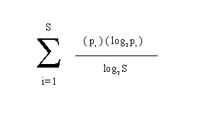
where i = ith wetland
pi = proportion of total wetland area in the i class
S = wetland class richness (number of
classes present)
**Distance to nearest wetland is the
minimum straight line distance to the nearest wetland that is
at least one-half as large as the wetland being evaluated.
***Inverse distance weighted sum is
a statistic that represents the relative amount of wetland within
500 meters of an evaluated wetland, with proportionately greater
weight given to those areas that are closer to the evaluated wetland.
The raw sum is divided by the total area of the 500 meter zone
surrounding the evaluated wetland so that the results for different
wetland units can be compared directly.
The ranking system used to determine Large and Complex Freshwater Wetlands for the Resource Protection Project has no legal significance for any regulatory purpose, and has not been adopted by RI Department of Environmental Management. The development of all wetlands, regardless of size, is regulated by state and federal agencies.