This page contains a default metadata document for a sample shapefile in the NPS Metadata Tools and Editor tab within ArcCatalog. This metadata is displayed using the "NPS Basic Edit " Stylesheet. This page highlights two sections of metadata that are mandatory for the NPS Profile and can only be edited using the MTE.

|
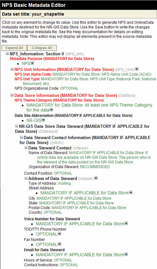
The two main metadata components of the NPS Profile that are not in the CSDGM are the NPS Info section and a couple extra Theme and Place Keywords. The screenshot at right only shows those two sections of the metadata in the MTE. Other fields can be edited in either the MTE or ArcCatalog, and changes made will be visible in both editors.
NPS Info: This section contains general information about the relevant park and Data Steward for the dataset. Green text indicates a field is either Optional or is Mandatory for the Data Store. Blue text indicates a field is Mandatory for FGDC compliance. You can edit fields by clicking in the green or blue text. Text that has been edited and saved will also be blue. The NPS Info section will likely contain identical information for many of your datasets. Th good news is, once you have completed this information for one dataset, you can use it as a template to fill in other metadata records. You can even apply your template to multiple datasets at once. See the link at the bottom of the page for more information about templates.
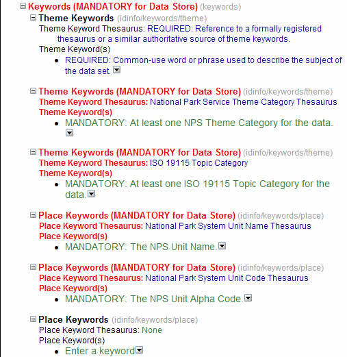
Keywords is another section that is slightly different in the NPS Profile. If you entered keywords using ArcCatalog, these keywords would appear where it says "Theme Keywords" or "Place Keywords" in black. You will also need to enter at least one NPS Theme Category Keyword and at least one ISO Topic Category Keyword where you see "Theme Keyword(s)" in red. You will also need to enter the Park Unit Name and Alpha Code where you see "Place Keyword(s)" in red. All of these Keywords are selected from drop-down lists. |
 |
Note: You cannot edit Entity & Attribute Information using the NPS MTE. This section is not mandatory according to the FGDC or the NPS Profile, but we HIGHLY recommend that you fill in this information. You will need to use ArcCatalog or another metadata editor other than the MTE to add Attribute Iinformation. |
|
| Main |
| Instruction |
| Standards |
| Examples |
| FAQ |
| Data Management |
| Tools |
| FTSC Home |